Sedona is known for its dramatic red rock landscapes and for its big outdoor adventures.
If you like hiking, this is a great place to get out on the trails. Just a few minutes from town, you’ll find paths that lead to huge rock formations and wide desert views. It’s easily one of the most scenic places in the American Southwest.
If you’re searching for the Best Hikes in Sedona, Arizona, for Incredible Red Rock Views, and for trails that make you stop every few minutes to experience its scenery, you’re in the right place. Below, I’ve shared some of the best hikes in Sedona that are truly worth exploring.
Disclaimer: This post may contain affiliate links. We may earn a commission if you purchase through these links, at no extra cost to you.
Table of Contents
ToggleHow to get there and get around
There are plenty of regular flights to Phoenix Sky Harbor International Airport. After landing, pick up a rental car and drive to Sedona, which takes about 2 hours. It’s the easiest way to reach the area and get quick access to the hiking trails.
Best Moderate Hikes in Sedona
Boynton Canyon Trail

- Distance: 6.1 Miles (round trip)
- Elevation Gain: 820 Feet Elevation Gain
- Difficulty: Moderate
- Fee: Red Rock Pass or America the Beautiful Pass required for parking
- Best Time of Day: Early morning or late afternoon to avoid crowds and heat
Boynton Canyon Trail is one of the most popular hikes around Sedona. The trail is known for its big red rock views, desert plants, and the vortex energy the area is famous for.
As you walk deeper into the canyon, the scenery changes a bit. You’ll pass open red rock areas and then sections with trees that give some shade along the trail. The mix of canyon views and forested spots makes it one of the best moderate hikes in Sedona.
Parking at the trailhead is limited, and since Boynton Canyon is a popular hike, the lot fills up quickly. If that happens, you may need to park along the roadside nearby. A parking pass is required to park in the main trailhead lot.
Soldier Pass Trail

- Distance: 4.5 Miles (round trip)
- Elevation Gain: 641 Feet Elevation Gain
- Difficulty: Moderate
- Fee: Red Rock Pass or America the Beautiful Pass required for parking
- Best Time of Day: Early morning to avoid crowds and midday heat
Soldier Pass Trail sits about 3.3 miles from downtown Sedona, less than a 10-minute drive. The trail runs through the Red Rock forest and is one of the more interesting hikes around Sedona because you pass a few natural landmarks along the way.
Not far from the start, you’ll reach Devil’s Kitchen, the largest sinkhole in Sedona, formed when underground caverns collapsed. A bit farther along the trail are the Seven Sacred Pools, a group of small natural pools that sometimes fill with water after rain.
Because of these stops along the trail, Soldier Pass is often considered one of the best moderate hikes in Sedona.
Parking here is very limited, with only 14 spaces. The trailhead lot is closed from Thursday to Sunday, so on those days you’ll need to use the free Sedona Shuttle (Route 14) from the Posse Grounds Park & Ride. From Monday to Wednesday, it’s best to get there before 8:00 AM if you want a parking spot.
Best Sedona Hikes for Views
Cathedral Rock Trail

- Distance: 1.1 Miles (round trip)
- Elevation Gain: 740 Feet Elevation Gain
- Difficulty: Moderate to Difficult
- Fee: Red Rock Pass or America the Beautiful Pass required for parking
- Best Time of Day: Sunrise or sunset for the best views and cooler temperatures
Cathedral Rock Trail is easily one of the best Sedona hikes for views, with incredible scenery from the top. It’s in the Red Rock Ranger District of the Coconino National Forest.
Hiking Cathedral Rock is one of the most popular things to do in Sedona. The trail is short, about 1.1 miles, but it’s steep with around 740 feet of elevation gain. You’ll need to scramble over rocks in a few sections, so it’s not a casual walk, but the views at the top make it worth the effort. Bring your camera, you’ll want it.
Parking at the trailhead is limited and fills up quickly, especially during busy times. On peak days, the Sedona Shuttle runs (usually Thursday to Sunday, holidays, and busy seasons). During those hours, private cars aren’t allowed at the trailhead, so you’ll need to use the shuttle instead.
Doe Mountain Trail

- Distance: 1.5 Miles (round trip)
- Elevation Gain: 400 Feet Elevation Gain
- Difficulty: Moderate
- Fee: Red Rock Pass or America the Beautiful Pass required for parking
- Best Time of Day: Sunset for the best views, or early morning for fewer crowds
Doe Mountain Trail is less than 10 miles west of Sedona, about a 20-minute drive. It’s also close to other popular trailheads like Devil’s Bridge, Boynton Canyon, and Bear Mountain, so it’s easy to add to your plan.
It’s a short and really rewarding hike, which is why it fits into almost any Sedona trip. The main reason people come here is for the views from the flat mesa at the top, and because of that, it’s often listed as one of the best Sedona hikes for views.
The climb up has some incline, so you’ll feel it, but it’s still manageable. Once you reach the top, it opens into a wide, flat space where you can walk around and take in the views from all sides.
Best Hikes in Sedona with Water
West Fork Trail (Oak Creek Canyon)

- Distance: 6.9 Miles (round trip)
- Elevation Gain: 400 Feet Elevation Gain
- Difficulty: Moderate
- Fee: Parking fee $15 per vehicle (up to 5 people)
- Best Time of Day: Morning for fewer crowds, or midday for better lighting inside the canyon
West Fork Trail is one of the most well-known hikes around Sedona, and easily one of the best hikes in Sedona with water.
The trail sits in Oak Creek Canyon and runs about 6.9 miles round-trip. Along the way, you’ll walk through tall canyon walls, shaded forest sections, and cross the creek multiple times, usually around 10 or more. In the fall, the colors here really stand out.
You don’t need a Red Rock Pass for this hike, but you do have to pay for parking at the Call of the Canyon Day Use Area. The trail is fairly flat, so it works well for families and even dogs, but the creek crossings keep it interesting the whole way.
Baldwin Trail to Red Rock Crossing

- Distance: 2.5 to 3 Miles (round trip)
- Elevation Gain: 300 Feet Elevation Gain
- Difficulty: Easy to Moderate
- Fee: Red Rock Pass or America the Beautiful Pass required for parking
- Best Time of Day: Sunrise or sunset for the best views of Cathedral Rock
Baldwin Trail to Red Rock Crossing is an easy and scenic hike in Sedona. If you’re looking for water views without a tough climb, this is a good option and is often listed as one of the best hikes in Sedona with water.
The trail is mostly flat and easy to follow. You’ll walk through open desert with wide views of the red rocks along the way.
At the end, you reach Red Rock Crossing, where Oak Creek flows with Cathedral Rock right in front. It’s a well-known spot, especially around sunrise and sunset when the light reflects on the water.
Best hikes in Sedona, Arizona, with waterfalls
Seven Sacred Pools via Soldier Pass

- Distance: 4.5 Miles (round trip)
- Elevation Gain: 650 Feet Elevation Gain
- Difficulty: Moderate
- Fee: Red Rock Pass or America the Beautiful Pass required for parking
- Best Time of Day: Early morning for fewer crowds and cooler temperatures
Seven Sacred Pools via Soldier Pass is one of the more interesting hikes in Sedona, especially after rain, when the rock pools actually hold water. The hike starts on Soldier Pass Trail and quickly brings you to two well-known spots, Devil’s Kitchen sinkhole and the Seven Sacred Pools.
The pools are small basins in the red rock, and while this isn’t a big waterfall hike, the area looks much better when water is moving through after rain. Past the pools, the trail continues through classic Sedona scenery with desert plants, red rock walls, and open canyon views.
Because water here is seasonal, this trail is often included among the best hikes in Sedona, Arizona, with waterfalls.
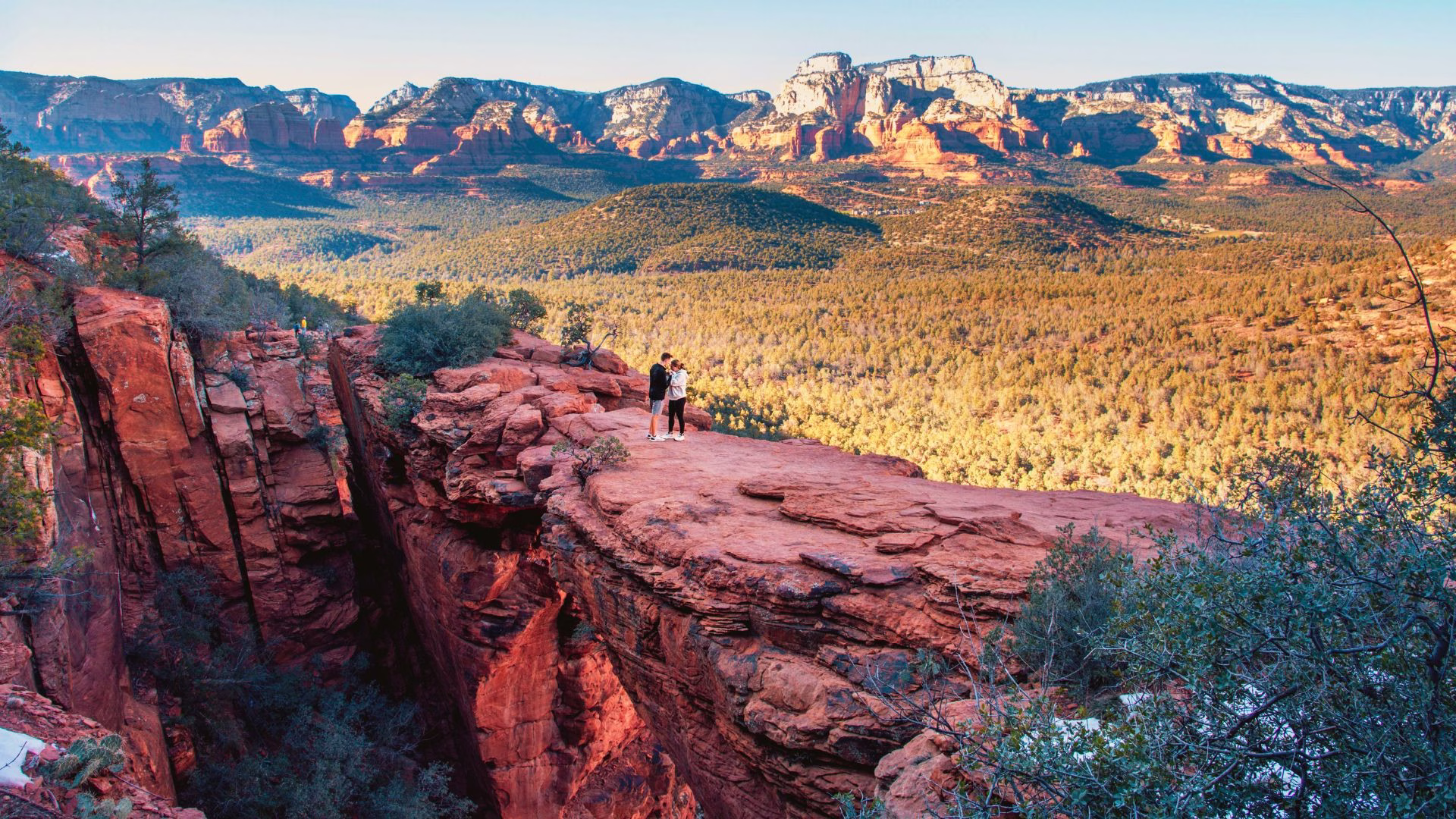
Devil’s Bridge Hike Sedona via Mescal Trailhead

- Distance: 4.2 Miles (round trip)
- Elevation Gain: 520 Feet Elevation Gain
- Difficulty: Moderate
- Fee: Red Rock Pass or America the Beautiful Pass required for parking
- Best Time of Day: Early morning to avoid crowds and heat
Devil’s Bridge Hike via Mescal Trailhead is one of the better ways to reach Sedona’s famous natural sandstone arch, especially if you want to avoid the rough road used on some of the other routes.
From Mescal Trailhead, the hike starts with about a mile of mostly flat trail through open desert. This section is also used by mountain bikers, so it’s worth staying alert. After that, you connect to Chuckwagon Trail, which moves through short forested patches and a few small ups and downs.
Along the way, you’ll see cacti, yucca, and plenty of red rock scenery before reaching the Dry Creek Road and Devil’s Bridge Trailhead junction. Going this way, the full hike is about 4.2 miles round trip, and it offers one of the best experiences.
Where to Stay in Sedona, Arizona
Because Sedona is so popular, hotels can sell out quickly, especially in busy seasons. If you’re sure you’ll be exploring around Sedona, it’s best to book early.
Tips for Hiking in Sedona
- Buy a Red Rock Pass before you arrive in Sedona, print it out, and leave it on your car dashboard. Most trailheads in the area require it.
- If you don’t want to get to the trailhead super early, the Sedona Shuttle can be really useful since parking is limited at many popular hikes. Otherwise, try to arrive as early as possible.
- It’s also a good idea to download your trail maps before heading out, because phone signal can be unreliable once you’re on the trail.
- Starting early helps a lot in Sedona. The trails are very popular, parking fills up fast, and the earlier you go, the better your chances of getting a spot and enjoying the hike before it gets crowded.
- Bring plenty of water. Sedona gets very hot in summer, and even the rest of the year can feel warm, especially on exposed trails. It’s easy to get dehydrated, so carry more water than you think you’ll need.
- Wear proper hiking shoes with a good grip. Most of the trails are rocky and uneven, so having solid footwear really makes a difference.
What to Plan and Book for Your Sedona Hiking Trip
Flights — Trip.com is useful for comparing and booking flights into Phoenix Sky Harbor International Airport, which is the main gateway for reaching Sedona.
Car rental — DiscoverCars makes it easy to rent a car from Phoenix, which helps a lot when getting to trailheads like Cathedral Rock, Devil’s Bridge, and Boynton Canyon.
Tours — GetYourGuide works well for booking guided hikes, jeep tours, and off-road trips, especially for places like Devil’s Bridge, where the access road can be rough.
Hotels — Booking.com helps you find places to stay in Sedona close to the trailheads. That makes a difference since parking fills up early at most hikes.
Connectivity — Saily eSIM helps keep maps and trail routes working, even in areas where signal drops, which happens a lot around canyons.
Travel insurance — SafetyWing covers hiking trips, outdoor activities, and unexpected travel issues while you’re on the road.
After exploring the best hikes in Sedona, Arizona, if you’re looking for more travel ideas across the USA, check out these blog posts.